Introduction
Kenton Connects is a countywide project, which examines and makes recommendations for bicycle and pedestrian modes of transportation. Kenton County is home to nearly 169,000 residents that utilize all modes of transportation including cars and trucks, public transportation, bicycles, and by foot. While bicycling and walking are used less frequently than other modes of transportation, they are nonetheless important to Kenton County and have been identified in the Kenton County Comprehensive Plan as a priority.
The previous bicycle and pedestrian plans were created in 1999 and 2001, respectively. Bicycle and pedestrian issues and demand have changed in the last several years and those original plans have steadily become less relevant. The Kenton Connects study represents a comprehensive analysis of bicycle and pedestrian issues in Kenton County throughout 2017 and 2018.
Preparatory data collection efforts for the study began in early 2017 and included initial existing conditions research and a comparative jurisdiction analysis. This document describes the existing bicycle and pedestrian conditions in Kenton County in 2017 and 2018, the planning process, and methodology for the study. Information found throughout this text served as the basis for bicycle and pedestrian recommendations that are intended to be incorporated into the Kenton County Comprehensive Plan.
This research chapter examines the role of bicycle and pedestrian transportation in Kenton County and provides a comprehensive examination of these modes of transportation as they exist in early 2018.
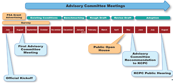
The study officially commenced in July 2017 with the release of three bicycle and pedestrian public service announcements (PSA). The PSA’s were a project completed by Planning and Development Services of Kenton County (PDS) and made possible through the Paula Nye Grant. Funds from the grant were used to create three bicycle and pedestrian PSA’s designed to promote bicycle and pedestrian education and awareness. The three PSA’s covered topics including Bicycle Safety, Pedestrian Safety, and Driver’s Safety.
In preparation for the first Advisory Committee meeting, staff researched existing bicycle and pedestrian conditions such as bicycle lanes, sidewalks, and multi-use paths. The first Advisory Committee meeting occurred on August 30, 2017, and met approximately every other month throughout the end of the planning process.
The Kenton Connects survey was available to the public beginning on July 1, 2017, and was open for participation through October 9, 2017. The findings from the survey were presented to the Advisory Committee on October 25, 2017. The results of the survey provided guidance for the study moving forward and the next phase of the project, benchmarking.
Benchmarking was done to create goals and strategies for key measurables related to the study which can be reviewed in the future to evaluate success. The benchmarking portion of the study lasted from November 2017 through January 2017 and the results were used to begin crafting strategies and recommendations for the final plan. The recommendations were presented at a public open house on May 16, 2018. The final approvals of the plan began in May 2018 with subsequent public hearings in June and August. KCPC considered the recommendation from the study on August 2, 2018, and adopted it as an amendment of the Direction 2030 comprehensive plan.
Public Involvement
Public input is essential in every planning effort. The planning process included public input to create a plan that is reflective of their needs. The public input methods utilized are described below.
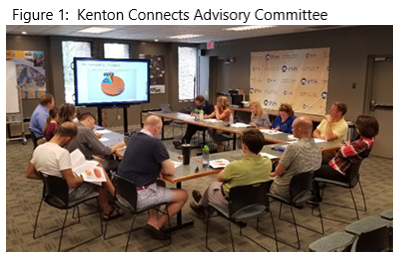 The Advisory Committee was created to provide the primary citizen and expert involvement during the study. The group provided guidance and oversight to staff and helped lead the general direction of the study. In the summer of 2017, an 18-member Advisory Committee was assembled, which consisted of local residents, business owners, elected officials, and professionals. Advisory Committee members were invited to participate based on their personal interest in bicycle and pedestrian issues or to provide professional expertise throughout the study. The group worked with staff to learn, contemplate, discuss, and make decisions on a variety of issues related to active transportation. The Advisory Committee recommended the plan be submitted to KCPC for their consideration as part of Direction 2030.
A public meeting provided additional opportunities for the citizens to provide input and have their voices be heard. The result of this input was presented to and considered by the advisory committee for inclusion in the plan.
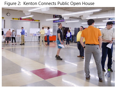 A public meeting was held on May 16, 2018, at Dixie Heights High School. This meeting was an open house style meeting which provided the public with the opportunity to see key ideas from the study and provide comments on the plan. Approximately twenty-five people attended the open house and provided their thoughts. The open house style meeting provided participants the opportunity to view existing conditions research and key recommendation areas from the study: connectivity, safety, usership, and education.
The existing conditions and recommendation ideas from the study were displayed on boards that allowed participants to move throughout the meeting at their own pace and ask questions of staff and advisory committee members who were present at each station. Each participant also had the opportunity to submit a comment card providing their thoughts on the key ideas. General reaction to the plan, its ideas, and findings were positive and were reviewed by the advisory committee. A summary of the open house comment cards is provided in the Kenton Connects Public Comments Report.
Throughout July, August, and September 2017, a survey was conducted. The survey was designed to gather information about bicycle and pedestrian conditions and issues in Kenton County. The survey was open to the general public and gathered opinions of people ranging from novice pedestrians to expert-level cyclists as well as motorists who utilize the roadways. Questions were broad and included topics dealing with bicycle and pedestrian safety, education, and infrastructure improvements. A condensed version of the survey was provided to local high school students to gain a better understanding of bicycle and pedestrian concerns for that age group.
The survey was available electronically via the Kenton Connects website from July through September 2017. Paper forms of the survey were made available at Kenton County Public Library locations, Covington Housing Authority, and to those who requested it. Overall, 424 full length surveys were completed, and fifty-nine condensed versions were submitted by high school students.
The four key themes identified from the results of the survey were:
- Improving bicycle and pedestrian safety.
- Providing better access to bicycle and pedestrian infrastructure.
- Improving connectivity of the existing bicycle and pedestrian system.
- Improving the convenience and usability of walking and biking as both a form of recreation and transportation.
The advisory committee moved forward with these key themes and used the results of the survey to help guide the direction of the final plan and recommendations. Results and details of the survey can be found in the Kenton Connects Public Comments Report
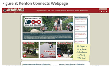 A project website was created to promote the study and inform citizens about bicycle and pedestrian related issues prior to the official kickoff of the Kenton Connects study. KentonConnects.org provided those interested in the study with the opportunity to sign up for an email list, which was used to inform people of the public meeting and updates about the study. The electronic version of the survey was hosted on this website and provided the main source of contact for users. Periodic updates to the website were made to inform citizens about bicycle and pedestrian related issues and inform citizens on the status of the study.
Paula Nye Grant Public Service Announcement’s
Coinciding with the kickoff of the Kenton Connects study, three public service announcements promoting bicycle and pedestrian safety and education were created. These public service announcements were made possible by the Kentucky Transportation Cabinet (KYTC) through the generous award of a Paula Nye Grant. The grant is funded through citizen donations during the purchase or renewal of the “Share the Road” license plates and is awarded annually to organizations interested in informing and educating Kentuckians on bicycle and pedestrian transportation safety issues.
PDS staff generated three videos focused on educating the public about bicycle, pedestrian, and driver safety. They help teach the rules of the road and work to create a safer transportation environment. The final 5 seconds of the PSA’s were used to promote the Kenton Connects study and encourage people to visit the website where they could take the survey.
The three videos were advertised on the Spectrum television and digital media network and social media outlets such as Facebook and YouTube. The majority of the funds from the grant were used to pay for the advertising portion of the project. The creation of the PSA’s provided a great opportunity to educate the public about bicycle and pedestrian safety and promote the kickoff of the Kenton Connects study. The three PSA pages can be found at https://www.youtube.com/@pdsofkentoncounty521/videos.
Study Overview, Vision, and Goals
A vision statement and study goals were established by the Advisory Committee to help guide the direction of the study. The following sections briefly review the considerations taken into account during the planning process.
Vision and Goals
The following vision statement and goals for the project were used to guide the development of the plan throughout the process and served as the framework upon which the recommendations were created.
The vision of the Kenton Connects Study is to improve bicycle and pedestrian conditions and usability in Kenton County by strengthening and building upon existing infrastructure, creating policies that encourage a friendlier bicycle and pedestrian culture, and ensuring Kenton County is prepared for a strong bicycle and pedestrian future.
Kenton County encompasses a total of 165 square miles and presents a wide array of issues for any type of planning process. The unique urban, first-ring suburban, suburban, and rural development patterns that exist from north to south requires the examination of a wide range of bicycle and pedestrian issues that are exclusive to certain parts of the county. A goal of this project is to create a plan that addresses bicycle and pedestrian needs throughout Kenton County and provide recommendations for future bicycle and pedestrian opportunities for all types of users.
The following study goals were established early in the Kenton Connects study process by the advisory committee. These goals were initially established with guidance from the existing recommendations and tasks found within the Direction 2030 comprehensive plan. They are intended to be achievable and attainable goals that would promote bicycle and pedestrian modes of transportation in Kenton County.
- Strive to create a friendlier and safer bicycle and pedestrian environment in Kenton County
- through education, improved infrastructure, and establishing a bicycle and pedestrian culture.
- Establish a record of existing bicycle and pedestrian conditions and facilities in Kenton County including identifying current gaps in the system and an inventory of existing infrastructure.
- Identify problematic bicycle and pedestrian crash locations and craft strategies to improve these areas. Identify bicycle and pedestrian shed areas based on topography and ease of use.
- Establish benchmarks to create achievable goals and to identify strategies which can be used to help determine the success of the plan in the future. Benchmarks can be established for different sets of data including the number of crashes, mileage of facilities, and bicycle and pedestrian usage at key locations.
- Create bicycle and pedestrian policies that encourage and maximize the usership, convenience, safety, and functionality of these transportation options.
The Kenton Connects study is designed to address bicycle and pedestrian related issues in Kenton County. This section of the research report describes challenges and opportunities discovered throughout the public involvement and research phases of the project in 2017. To accomplish the goals of the study, implementation will need to be enacted on the local level and leadership will continue to be needed to bring these ideas to fruition. These respective subsections outline the most frequently mentioned topics discussed during the survey, public meeting, and advisory committee meeting.
Resources
Bicycle and pedestrian resources in Kenton County range from physical assets such as existing infrastructure like sidewalks and trails to advocacy and education organizations. The following subsections address bicycle and pedestrian resources that exist in Kenton County.
Physical Infrastructure
The infrastructure that exists in Kenton County is a solid foundation for the expansion of the system and to grow bicycling and walking modes of transportation. Resources that were identified through the research and survey phases of this project include multi-use trails, sidewalks, and mountain bike trails. These resources can be found sporadically throughout Kenton County in amenities such as Riverfront Commons, Licking River Greenway, Devou Park, and the Kenton County Park system. These areas, as well as others in Kenton County, were identified by survey respondents as great resources for active transportation. They provide access to sidewalks and other infrastructure that make these forms of transportation more accessible. Many of the ideas and recommendations identified in this study work toward strengthening identified existing bicycle and pedestrian resources and building upon existing assets.
Advocacy and Education
Advocacy organizations promote and encourage successful bicycle and pedestrian plans that will improve these modes of transportation in Kenton County. Organizations that promote and advocate for bicycle and pedestrian transportation include Tri-State Trails, Queen City Bike, and Cincinnati Off Road Alliance. These organizations work toward educating citizens about bicycle and pedestrian issues and seek to advance a vision for these modes of transportation. Advocacy and education by these types of organizations promote the safe and effective use of active transportation, help bring awareness to related issues, and try to bring people together toward a common goal.
Challenges
Numerous bicycling and pedestrian challenges were identified throughout the study. The result of the Kenton Connects survey identified four areas that present challenges to bicycling and walking in Kenton County. The following subsections address the challenges related to each of these four areas.
Safety
Safety was identified in the survey as a major barrier to bicycling and walking. The perception of safety, or the lack thereof, was something that prevented people from using these modes of transportation more often. The feeling or perception that bicycling and walking are not safe is a major challenge toward these becoming better transportation options. The survey results indicated that separation from traffic improves the feeling of safety and enhances the level of comfort. Identifying strategies and policies to improve the safety of bicycling and walking is an important component of this study.
Access
Access to usable and desirable bicycling and walking infrastructure in Kenton County is limited. Comments from the survey stated that community members drive outside of the county to walk or ride a bicycle because the accessibility and usability of their trails and paths is better. These people are willing to travel a greater distance to access infrastructure that meets their needs. Providing better access to places people want to bicycle and walk is a challenge which should be addressed to create a better bicycling and walking environment. This plan has sought to create strategies that will improve access to desirable infrastructure that improves connectivity and encourages their use.
Connectivity
The connectivity of the current bicycle and pedestrian system was identified by the survey as another obstacle to using the current system. In many areas sidewalks only connect within a subdivision or community and do not connect to a larger network or to destination type places. The bicycle lane system in Kenton County is limited and provides little connection to places of interest. The challenge is to begin connecting these systems to create a network which better serves the residents of Kenton County.
Convenience
Convenience refers to how easy, expedient, and friendly it is to use the current bicycle and pedestrian systems in Kenton County. Many people in the survey indicated that they do not bicycle or walk to work or for pleasure because it is not convenient to use these modes of transportation. This inconvenience is the result of the previous challenge areas including the lack of connectivity and access and the perception of safety. Working toward improving the other challenge areas will improve the convenience of bicycling and walking in Kenton County
The following subsections of this chapter provide information on research efforts and offer analysis pertaining to existing studies, plans, infrastructure, and facilities.
Review of Existing Studies
To ensure every effort has been made to create recommendations that will have the highest success, a review of previous bicycle and pedestrian related planning efforts in Kenton County was conducted. Reviewing these documents provides valuable insight into historic and previous conditions, concerns, and efforts related to bicycle and pedestrian modes. Seven plans were reviewed with respect to their relevance to the Kenton Connects study and how they relate to bicycling and walking in Kenton County. The plans and their recommendations are noted to ensure any recommendations made within the Kenton Connects study are made in the context of other plans or activities already taking place.
Current Bicycle and Pedestrian Trends
The advisory committee found it important to review other jurisdictions strategies to stay current on trends and create effective policies. Following other jurisdictions lead, Kenton County can learn and improve from their achievements as well as their mistakes. Effective bicycle and pedestrian strategies and policies can be adapted to fit Kenton County’s goals and needs.
Throughout the United States, numerous jurisdictions are adopting policies that create and encourage bicycle and pedestrian friendly communities.
Examples of infrastructure improvements, community education, and policy decisions can be seen on the local level throughout the country.
Infrastructure improvements are being made to improve the safety of pedestrians and cyclists, and to increase the number of trails, bike lanes, and overall infrastructure miles. When undergoing road construction, roads are being retrofitted to accommodate wider sidewalks, bike lanes, separated shared use paths, or other improvements. Additionally, when planning for future streets or improvements, bicycle and pedestrian needs are being taken into consideration during the initial planning and design phase.
With infrastructure in place, many cities and organizations are taking the initiative to sponsor classes for bicycle and pedestrian education and safety purposes. They are also hosting community events that may include walking or biking guided tours that promote a positive pedestrian and bicycle culture.
Cities Identified in Direction 2030
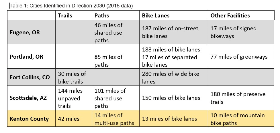
As identified in Direction 2030, the cities of Portland, Oregon; Eugene, Oregon; Fort Collins, Colorado; and Scottsdale, Arizona were determined to be comparable to Kenton County in either geographic size or in population. Portland, Scottsdale, and Kenton County are similar in geographic size between approximately 145 and 185 square miles. Eugene, Fort Collins, and Kenton County have similar populations of approximately 165,000 people according to the most recent public Census data.
An analysis of the five jurisdictions shows Kenton County has the least number of multi-use paths and bicycle lanes. Table 1 shows the number of trails, paths, and bike lanes accounted for in each jurisdiction.
Portland has grown to be nationally recognized as a bicycle hub, having one of the highest percentages of bicycle commuters in the nation for a large city. The city makes cycling and walking accessible and easy for its residents by providing maps and advocating for shorter trips to be made on foot or by bicycle. The city and affiliated organizations offer guided bike tours and classes that teach residents how to shop for a bicycle right for them as well as basic bicycle maintenance. In the city ordinance, there are regulations pertaining to bicycle parking. There are bicycle parking minimum requirements, standards for acceptable bike parking facilities, and ways to substitute bicycle parking for vehicular parking spaces. Additionally, in partnership with the Bicycle Transportation Alliance, Bicycle Safety Education is taught to fifth grade students at 40 Portland schools every year.
The City of Eugene continuously makes targeted infrastructure improvements to increase safety, while fostering a community culture supporting walking and biking as important transportation modes. Infrastructure enhancements include bike lanes added on both sides of the street during scheduled improvements and the Amazon Active Transportation Corridor.
The Amazon Active Transportation Corridor is a multi-use path designed to increase active transportation and connectivity in Eugene. This Corridor project design was created through community workshops open to the public and is funded by the Department of Transportation. Included in the Corridor plans is the construction of two new pedestrian bridges across a creek and extending the Amazon Path into a nearby park by widening a portion of the sidewalk. To take advantage of these improvements, the launch of the city’s new bike share program is tentatively scheduled for April 2018.
Located north of the capital City of Denver, Fort Collins has earned the Platinum award for a Bicycle Friendly City by the League of American Bicyclists. One reason the city received this award is because of the targeted approach to community engagement and the reception of walking and bicycling through education and encouragement. For example, the city supports educational classes, such as a bicycle friendly driver certification for motorists and lessons on cycling in winter. Not only does Fort Collins offer classes for residents to take, but they also host an Open Streets event. Open Streets is a national program that restricts city blocks from vehicular traffic for an allotted time to demonstrate that routes are walkable and bikeable on a daily basis. Additionally, their bike share program, Zagster, has GPS and phone application capabilities with nineteen docking station locations.
In 2015, Scottsdale was awarded the Gold Level Bicycle Friendly Community by the League of American Bicyclist. Located just outside of Phoenix, Scottsdale promotes the health and environmental benefits of walking and bicycling as evidenced by this award. The city hosts a portion of the Arizona Canal Multi-use Path; a 17-mile loop through multiple cities displaying colored concrete paths, public art, pedestrian bridges, and other enhancements. A multi-use path of this nature encourages bicycling and walking for recreational uses as well as for commuting to and from work. A self-guided bicycle tour is available along the Mountain Vista Route to residents and visitors of Scottsdale to promote various bicycle routes.
Review of Nearby Jurisdictions
The review of current trends also included an evaluation of bicycle and pedestrian friendly policy decisions in Boone County, Louisville, and Lexington, to provide a regional comparison. Kenton County currently has no regulations or requirements for bicycle parking, whereas these aforementioned jurisdictions have existing zoning regulations primarily focused on bicycle parking.
Located immediately west of Kenton County, Boone County has adopted bicycle parking minimums in many zones, making bicycle parking in new developments required. Specifically, the cities of Florence, Walton, and Union require at least two bicycle parking spaces for each twenty-five vehicular parking spaces in each new development or building. Sidewalk provisions within the county follow the Boone County Subdivision Regulations, which state that sidewalks shall be provided on one or both sides of the street dependent on density. Between parking areas and building entrances lighting is required on pedestrian walkways.
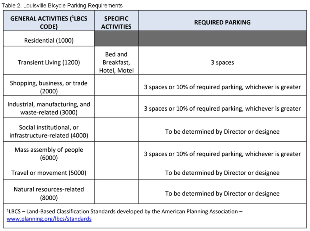
The City of Louisville is working towards creating a positive culture that encourages walking and bicycling as viable modes of transportation. Louisville has bicycle parking minimums in residential, commercial, industrial, and institutional locations. The city requires bicycle parking based on the associated type of use. Table 2 shows an example of how the number of bicycle parking spaces are required in Louisville. Developers are also offered the option to have bicycle parking in lieu of vehicular parking spaces. After the bicycle minimums are met, for every five more bicycle parking spaces, the vehicular parking spaces may be reduced by one space. Bicycle parking may substitute up to 5% of the required vehicular parking spaces.
Louisville also has its own city bicycle laws that supplement the State laws already in place. City laws state that residents over the age of eleven should not ride their bicycles on the sidewalk and those under the age of eighteen must wear a helmet. Local vehicular laws for drivers concerning bicycles and pedestrians include allowing three feet between the cyclist and the vehicle when passing and to look for cyclists when opening the car door after parking.
Updated in 2009, the City of Lexington Zoning Ordinance outlines bicycle parking minimums and offers bicycle parking in lieu of vehicular parking. For multi-family projects, four bicycle rack spaces shall be provided for every three units with a maximum requirement of twelve spaces. Lexington also allows those developments which will have more than fifty vehicular parking spaces an option to reduce their required vehicular parking spaces by providing a permanent bicycle rack.
Kentucky State Laws and Regulations
The Kentucky Revised Statute (KRS) encompasses several laws to help provide for a safer environment for active transportation users. Regulations such as requiring lights, reflectors, and a horn or other sound device provide safety measures for bicyclists which make them more visible and noticeable to drivers. The Kentucky Bicycle Safety Standards administrative regulation provides rules relating to the proper and safe way to ride a bicycle; for example, how to signal for and execute a left turn or how to pass a slower moving vehicle. The most recently passed pedestrian law relates to the visually impaired and states that vehicles must yield the right-of-way to any blind pedestrian carrying a white cane or utilizing an assistance dog. It is anticipated that future legislature will continue to improve safety for bicyclists, pedestrians, and vehicle operators.
In 2018, there were two bills in the state legislature. House Bill (HB) 52 was a bill that would require anyone under the age of twelve to wear a bicycle helmet when riding a bicycle. HB 52 was not approved. HB 33 would require a vehicle driver to give at least three feet of distance between the vehicle and the bicycle when passing a cyclist. HB 33 was approved. These proposed laws were common in other states and will work to make cycling safer in the Commonwealth.
The Kentucky Driver’s Manual is a statewide handbook that provides driving rules for the citizens of Kentucky. Residents must have knowledge of the information before taking a written test to receive a driver’s license. The manual is maintained by the Kentucky State Police Department and is updated as needed, such as when new state legislation is passed. Specifically, there is one chapter pertaining to bicycle rules. Pedestrian safety information is located sporadically throughout the manual. The bicycle safety chapter includes rules for bicyclists such as using hand signals, riding on the correct side of the road, and obeying official traffic control signals and signs. The manual also provides rules for motorists concerning bicycles such as sharing the road, passing only when it is safe, and checking for bicyclists before opening your door.
Types of Cyclists
People who ride bicycles are made up of all age groups, skill levels, and motivational reasons for riding. There is no one-size-fits all approach to creating bicycle recommendations. Recommendations are intended to create a better bicycle environment for all levels of users. A goal of this study is to improve bicycle conditions in Kenton County for all users to help provide a better quality of life. There are three skill levels for cyclists: basic, intermediate, and advanced. The following subsections describe the comfortable levels and typical goals for each of the three levels.
The basic cyclist rides because it is fun and is typically done at a leisurely pace for pleasure. They are typically casual adult riders, new adult riders, children, or teenage riders. They traditionally prefer well defined separated bike paths so there is no conflict with vehicles and there is an increased feeling of safety. Easy and safe access to infrastructure is important.
Intermediately skilled cyclists are comfortable riding on separated bicycle paths or on local streets without heavy traffic. They ride bicycles for leisure or exercise purposes and may also ride for transportation needs but are not as experienced as advanced cyclists.
Advanced cyclists are comfortable operating under most traffic conditions and prefer direct access to destinations using the street system. They prefer riding at maximum speeds and the existing road system typically serves their needs. Advanced cyclists are typically more confident with riding safely on the road. Their ability to understand the rules of the road and stay safe in the roadway system are critical.
Existing Bicycle and Pedestrian Conditions
In the initial phases of the Kenton Connects study a complete analysis of bicycle and pedestrian conditions in Kenton County was conducted. The following sections outline this research.
Separated Multi-Use Facilities
A separated multi-use path is a wide sidewalk that is physically separated from motor vehicle traffic by an open space or barrier. These paths can either be within a street right-of-way or within an independent right-of-way. A multi-use path is designed to be used by bicyclists, pedestrians, joggers, skaters, and other nonmotorized travelers. Figure 9 identifies the location of multi-use paths in Kenton County as of 2024, which totals approximately 24 miles. Examples of multi-use paths include the Licking River Greenway in Covington, Pride Park Trails in Taylor Mill, and Spring Valley Park Trail Erlanger. Riverfront Commons is a multi-use path located along the Ohio River in Covington and Ludlow with future plans to extend the existing path into Bromley and east into Campbell County.
As shown in Figure 9, the multi-use path network in Kenton County current lacks any major overall connectivity. Tri-State Trails has identified connectivity improvements throughout the region and has plans to connect these trails as much as possible. Multi-use paths were historically added in Kenton County when new subdivisions were created or within existing parks or open space. Subdivisions and parks currently lack connectivity to a greater multi-use path network or to other modes of transportation. Additionally, there is only one identified multi-use path located wholly within the Rural Sub Area as defined by Direction 2030, the Ryland Heights Wilderness Trail. All other multi-use paths are located in the Suburban, First-Ring, or Urban Sub Areas. The Kenton County Subdivision Regulations adopted in 2022 require the construction of a multi-use path in any subdivision with five hundred or more lots regardless of the location.
Existing Bicycle Facilities
Bicycle facilities are intended for bicycle use only and are not designed to accommodate other modes of transportation. Bicycle specific facilities that exist in Kenton County include bike lanes, mountain bike trails, bicycle parking facilities, and Red Bike.
 A bike lane is a designated area within a street or roadway reserved for bicycle travel. These facilities are separated from the rest of the roadway by painted lines or other pavement markings. Bike Lanes are typically identified within the street network with signage or on-street striping. They provide a specific bicycle lane for vehicle traffic, provide direct access to destinations via streets, and are most frequently utilized by intermediate or advanced bicyclists who can operate under most traffic conditions.
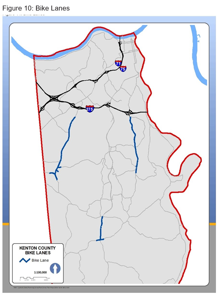
There are three existing bike lanes in Kenton County totaling approximately thirteen street miles. A street mile is defined as the total number of miles of the street going in both directions. For instance, a 1-mile stretch of road that has bike lanes going in both directions would have bicycle lanes totaling two street miles. The sum of bicycle lane street miles includes the addition of lanes going in each direction. These bike lanes are located on Turkeyfoot Road throughout Edgewood, Erlanger, and Elsmere; Pride Parkway in Taylor Mill; and KY 17 in Independence as shown in Figure 10. Existing bike lanes are limited in Kenton County and provide only a small fraction of transportation route options for the county’s residents. As with other bicycle and pedestrian facilities, the existing bike lanes provide very little connectivity to destinations throughout the county and do not link to a larger planned network. Each of the three identified bike lanes exist within the Suburban Sub Area.
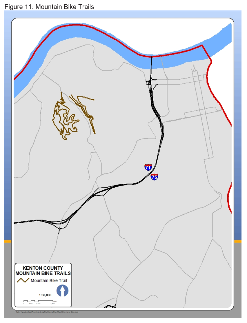 Mountain biking is the sport of riding bicycles off paved surfaces, often over rough terrain, using specially designed bicycles. Mountain bike trails are predominately used for recreation as opposed to transportation, and like many other facilities, consist of varying degrees of difficulty. The only identified mountain bike trails in Kenton County are located in and adjacent to Devou Park in the cities of Covington and Ludlow as shown in Figure 11. These trails provide opportunities for beginners to advanced mountain bikers in an off-road environment and in a form of recreation not available elsewhere in Kenton County. In total, there are approximately ten miles of mountain bike trails in Kenton County.
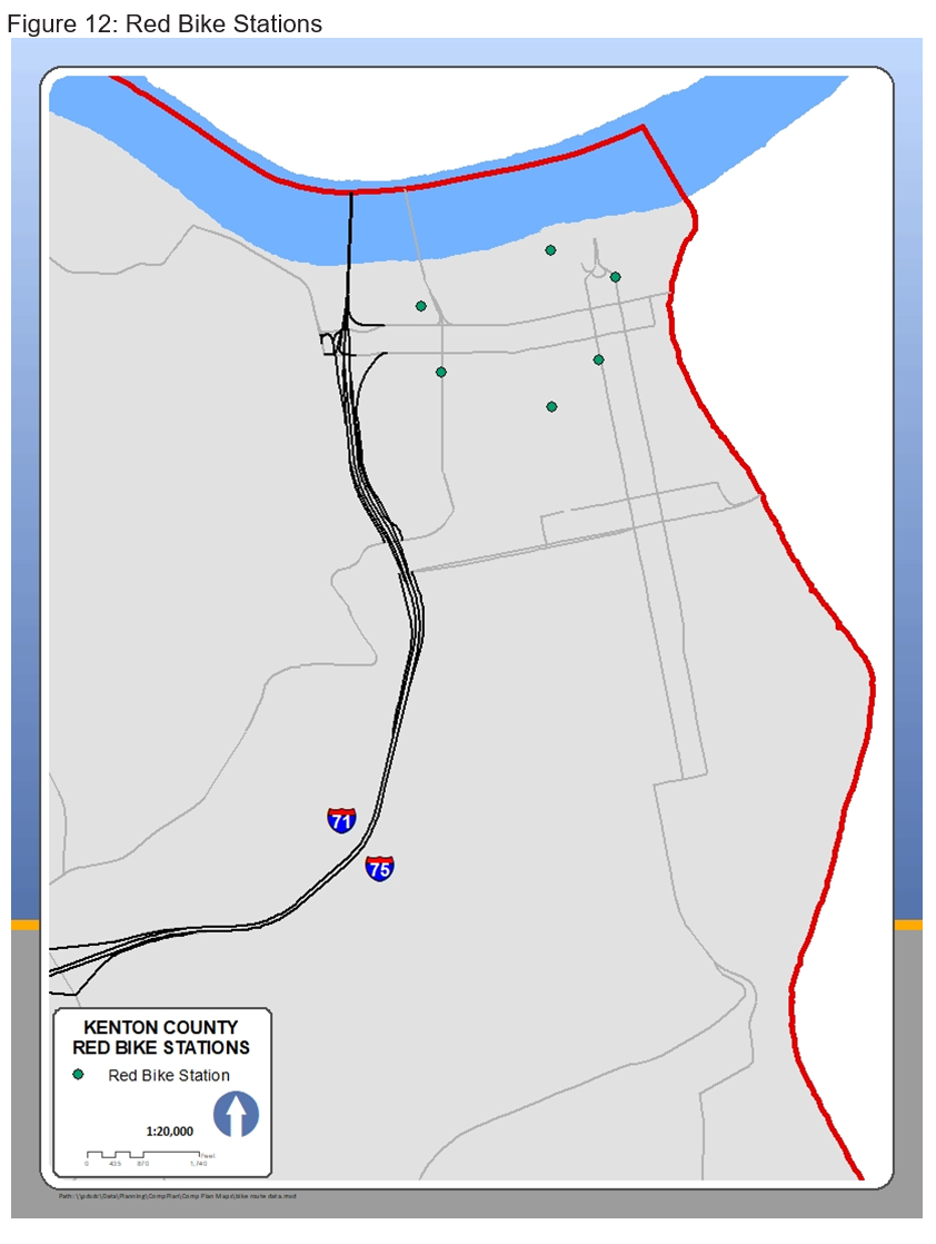 Red Bike is a bike sharing system consisting of fifty-seven stations and 442 bikes located in Hamilton County, Ohio, Campbell County, KY and Kenton County, KY. The service is dedicated to improving community by providing a low-cost, healthy, and green transportation option that makes a more vibrant and connected community. The system opened to the public in 2014 and as of January 2017 has had over 46,000 unique users. There are six Red Bike stations in Kenton County, all within the City of Covington as shown in Figure 12. Renting a Red Bike provides an opportunity to connect adjacent Campbell County with six stations and the City of Cincinnati with forty-five stations. Red Bike is designed for shorter trips and is a unique way to get around the riverfront and urban area of Northern Kentucky and Cincinnati.
Existing Pedestrian Facilities
Pedestrian infrastructure is intended to be used by people walking, jogging, or running. These facilities are not typically designed to accommodate other wheeled modes of transportation but are commonly utilized by bicycles and other inappropriate modes of transportation. Pedestrian specific facilities that exist in Kenton County include sidewalks and hiking trails.
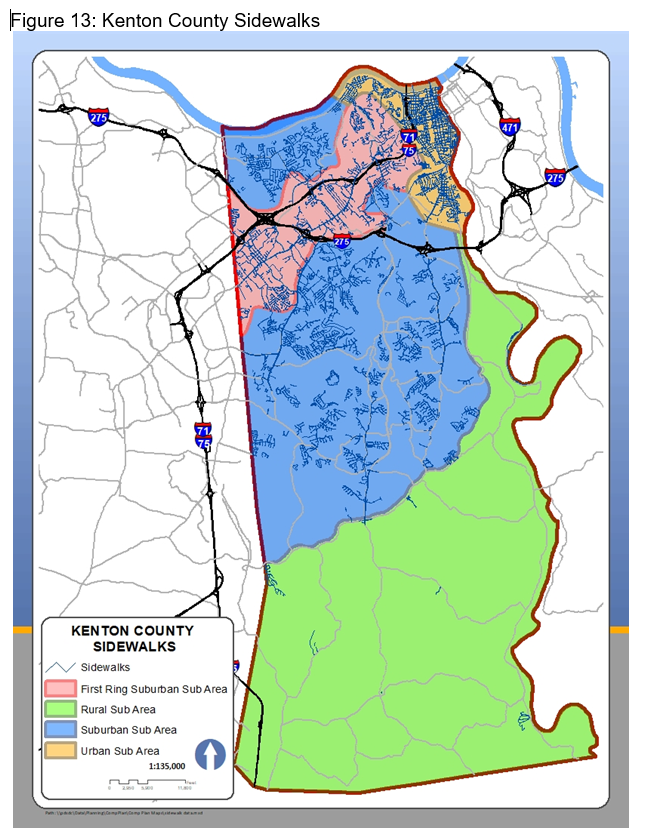 A sidewalk is a paved surface separated from vehicular travel lanes and used as a pedestrian walkway. Sidewalks are a common form of pedestrian infrastructure and are prevalent throughout most of Kenton County. Figure 13 shows the location of approximately 812 miles of sidewalks in Kenton County.
The density of sidewalks in Kenton County is much higher in the urban areas. The urban areas of the county have sidewalks on most of its streets, which were constructed years ago when the streets were installed. The sidewalk system in the urban areas is well connected. As development progressed southward into first ring and suburban areas requirements and standards for the construction of sidewalks varied over the years. The varied sidewalk requirements have created different standards and connectivity issues in different parts of the county. Sidewalks in the first-ring suburbs produced a disjointed pattern that was much less connected than the urban areas. Sidewalks in the suburban areas exist and connect on local streets within neighborhoods but much less so on arterial and collector streets that connect destination points. This has resulted in sidewalks connecting a neighborhood but not connecting entire areas of cities. Sidewalks are nearly nonexistent in the rural southern part of Kenton County which is a result of sparse sidewalk development pattern in this area.
The Kenton County Subdivision Regulations set specific rules that pertain to all subdivided lots in Kenton County. The most recent version of these regulations was adopted in 2022 and requires sidewalks on both sides of new streets in the urban and suburban focus areas (Figure 13) and generally pertains to those areas located north of KY 16. Areas located south of KY 16 in the rural focus area have different sidewalk requirements. In the rural focus area, if a new subdivision has less than 50 new lots, no sidewalks are required, and if a new subdivision has fifty or more lots, sidewalks are required on one side of the street.
In the urban, first ring, and suburban sub areas new sidewalks are required on both sides of the street and a perfect ratio would be 2:1; two sidewalk miles for every one street mile. The existing sidewalk system ranges from the highest ratio in the urban areas of sidewalks to streets at 1.42:1 to rural sub area only having a 0.07:1 ratio. This wide range of sidewalk to street ratios is indicative of the development patterns and varying subdivision regulations over time.
As with all other bicycle and pedestrian infrastructure, the connectivity of the sidewalk system is not complete. Many sidewalks only exist within subdivisions and do not connect outside the subdivision or to destination places such as economic centers or parks. Sidewalk gaps are locations where sidewalks do not exist which results in a disconnect between
two areas.
While there are many sidewalk gaps in Kenton County, there a few that, if constructed, would connect larger areas of the county. Prominent sidewalk gaps include Dixie Highway in Covington, Turkeyfoot Road in Crestview Hills, and Bristow Road in Unincorporated Kenton County. Eliminating these sidewalk gaps would link the urban sub area to the first ring sub area, connect larger areas with sidewalks to each other, and improve pedestrian walkability in the county.
Bicycle and Pedestrian Crash Information
Bicycle and pedestrian crashes represent only a small fraction of vehicle related crashes. Nonetheless, these statistics represent an important component in understanding and creating safe and practical bicycle and pedestrian related changes and improvements.
The Kentucky State Police maintain the Kentucky Collision Analysis for the Public database which allows anyone with interest to analyze data related to collisions occurring in the state of Kentucky.
It should be noted that the information in their database is dependent upon the accuracy and frequency in which local police departments enter information into the system. The database is searchable to specific crash types, such as a crash involving a bicycle, which are unique to Kenton County. Crashes can also be searched within an identified date range.
For the purposes of this study, bicycle and pedestrian crash data for Kenton County was extracted for the years 2012 through 2017. The extracted data provides basic information such as crash GPS coordinates, driving conditions, and limited details on the type of collision.
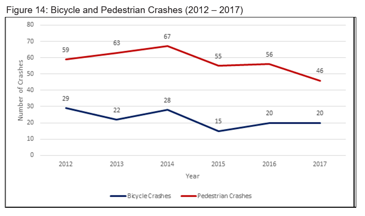
According to the database, during this date range there were 134 bicycle and 346 pedestrian related crashes in Kenton County as shown in Figure14. There was a slight decline in pedestrian crashes during this time and bicycle crashes stayed consistent. Without more data and information, it is difficult to determine the exact cause for the decrease in pedestrian related crashes.
Figure 15 shows the locations of bicycle crashes from 2012 through 2017 using a heat map. The heat map helps identify any concentrations of crashes that may exist. Bicycle crashes occur most often in the urban areas of Kenton County and along major corridors. Three concentrations of bicycle crashes appear on the heat map: Dixie Highway in Elsmere/ Erlanger, Fifth Street in Covington, and Madison Avenue in Covington.
Figure 16 shows the location of pedestrian crashes for the same timeframe, 2012 through 2017, using a heat map. As with bicycles, pedestrian crashes are occurring in the highest concentrations in urban areas and along major corridors. Concentrations of pedestrian crashes occur in the same area as bicycle crashes: Dixie Highway in Elsmere/Erlanger, Fifth Street in Covington, and Madison Avenue in Covington. Bicycle and pedestrian related crashes do occur in other parts of the county, but many appear to be isolated events that may or may not be related to larger issues.
The Fifth Street and Madison Avenue intersection and corridors represent major east-west and north-south arterials for the City of Covington. Vehicle traffic, in all forms, travels these routes due to their connectivity to destinations and their ability to move people.
In the Dixie Highway corridor in Elsmere/Erlanger, south of Commonwealth Avenue there were approximately fifteen bicycle and pedestrian related crashes. This corridor has many commercial businesses and provides a north-south arterial route in Kenton County and is generally not designed to safely accommodate bicycles, while safe pedestrian crossings are limited. Adjacent to this corridor is Lloyd Memorial High School which serves as the local high school for Erlanger and Elsmere. Many students walk to school from the adjacent neighborhoods. From 2012 through 2017 there were approximately eight pedestrian crashes.


Bicycle and Pedestrian Count Data
The number of bicyclists and pedestrians who use infrastructure in Kenton County can be difficult to quantify. To better understand the frequency in which bicycle and pedestrian infrastructure is being utilized, counts at key locations throughout the county have been conducted on a yearly basis, first by manual observation counts and more recently by mechanical counts.
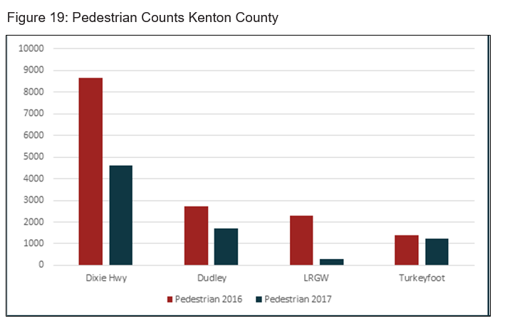
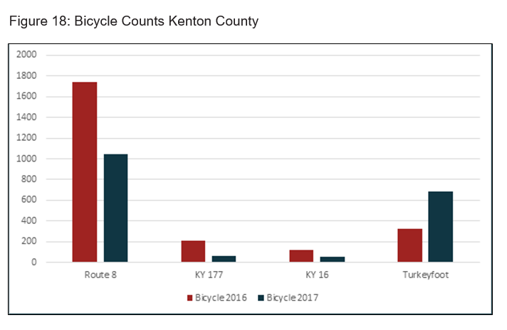
The recent mechanical counts have been conducted in conjunction with the Ohio Kentucky Indiana Regional Council of Governments (OKI) at seven locations in Kenton County. These counts were conducted during a two-week period in the months of May and June for 2016 and 2017.
Count locations were determined based on several factors including knowledge of frequently used routes, known high traffic bicycle and pedestrian areas, and the ability to obtain accurate data on a recurring basis. Figure 17 identifies the seven count locations in Kenton County and which modes of transportation were recorded.
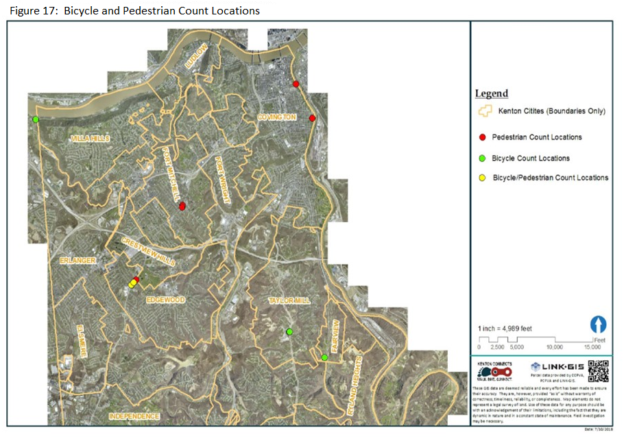
Pedestrian counts were recorded using a device called the Eco-Counter Pyrobox. These devices were attached to a utility pole or sign and pointed toward the sidewalk not the street. The box uses a sensor for detecting motion with passive-infrared technology and can distinguish between multiple pedestrians at one time.
Bicycle counts were recorded using a device called TRAX Cycles Plus. Pneumatic road tubes are placed on the roadway or bike path and collect data as cyclist’s ride over the tubes. This device can distinguish between cyclists and motor vehicles. The versatility of both pedestrian and bicycling count devices allows for complete and accurate count information.
Figure 18 and Figure 19 show bicycle and pedestrian count information for 2016 and 2017 as recorded using these devices. With just two years of data, it is difficult to recognize any trends or patterns in the count information, but future counts are anticipated. With OKI’s assistance counts will continue in 2018 and the following years. The count information will be used to build a solid foundation of data that can be analyzed to assist bicycle and pedestrian decision makers in the future.
Physical Environs
The physical nature of Kenton County provides a unique and challenging environment. The experience of riding a bicycle or taking a walk is affected by the physical terrain of an area. Kenton County has many ridges and valleys, which make it difficult for users unaccustomed to such topography to transverse using these modes of transportation.
This physical environment was considered when analyzing bicycle and pedestrian infrastructure and recommendations for the study. The road slope analysis tool provides an analysis of road slopes in Kenton County. It divides the slope of all roads in Kenton County into four categories: 0-4% slope, 5-8% slope, 9-12% slope, and 13% or greater slope. The higher slope areas are obviously more difficult to ride on a bicycle than lower slope areas. This information assists people in identifying low slope, low physical stress bicycle routes that otherwise may not have been known and helps encourage usage by casual bicyclists. It is an important tool in understanding the physical terrain barriers contributing to the lack of bicycle route connectivity.
Bicycling and walking also have a positive effect on the environment. Bicycling and walking are non-motorized forms of transportation and are proven ways to reduce greenhouse gases, fuel consumption, and congestion. The recommendations from this study promote the increased usage of bicycling and walking as modes of transportation which will have a positive impact on the environment.
Conclusion
Bicycle and pedestrian transportation comprise two pieces of a complex interconnected network that make up the overall transportation system. In order to effectively address the needs of all system users, it is important to consider bicycles and pedestrians within this network. The Direction 2030 plan and the Kenton County Transportation Plan have begun to examine broad mobility needs in Kenton County with bicycle and pedestrian concerns being a small portion of those plans.
The Kenton Connects study has examined existing bicycle and pedestrian conditions in Kenton County such as existing infrastructure, crash data, count information, and existing plans and best practices in an attempt to focus in on these modes of transportation. A comprehensive review and analysis of this data was outlined in this report and provides a snapshot of bicycle and pedestrian needs in Kenton County. The data collected and outlined also provides the basis for establishing goals and benchmarks for the advisory committee.


 The Advisory Committee was created to provide the primary citizen and expert involvement during the study. The group provided guidance and oversight to staff and helped lead the general direction of the study. In the summer of 2017, an 18-member Advisory Committee was assembled, which consisted of local residents, business owners, elected officials, and professionals. Advisory Committee members were invited to participate based on their personal interest in bicycle and pedestrian issues or to provide professional expertise throughout the study. The group worked with staff to learn, contemplate, discuss, and make decisions on a variety of issues related to active transportation. The Advisory Committee recommended the plan be submitted to KCPC for their consideration as part of Direction 2030.
 A public meeting was held on May 16, 2018, at Dixie Heights High School. This meeting was an open house style meeting which provided the public with the opportunity to see key ideas from the study and provide comments on the plan. Approximately twenty-five people attended the open house and provided their thoughts. The open house style meeting provided participants the opportunity to view existing conditions research and key recommendation areas from the study: connectivity, safety, usership, and education.
 A project website was created to promote the study and inform citizens about bicycle and pedestrian related issues prior to the official kickoff of the Kenton Connects study. KentonConnects.org provided those interested in the study with the opportunity to sign up for an email list, which was used to inform people of the public meeting and updates about the study. The electronic version of the survey was hosted on this website and provided the main source of contact for users. Periodic updates to the website were made to inform citizens about bicycle and pedestrian related issues and inform citizens on the status of the study.
 A bike lane is a designated area within a street or roadway reserved for bicycle travel. These facilities are separated from the rest of the roadway by painted lines or other pavement markings. Bike Lanes are typically identified within the street network with signage or on-street striping. They provide a specific bicycle lane for vehicle traffic, provide direct access to destinations via streets, and are most frequently utilized by intermediate or advanced bicyclists who can operate under most traffic conditions.
 Mountain biking is the sport of riding bicycles off paved surfaces, often over rough terrain, using specially designed bicycles. Mountain bike trails are predominately used for recreation as opposed to transportation, and like many other facilities, consist of varying degrees of difficulty. The only identified mountain bike trails in Kenton County are located in and adjacent to Devou Park in the cities of Covington and Ludlow as shown in Figure 11. These trails provide opportunities for beginners to advanced mountain bikers in an off-road environment and in a form of recreation not available elsewhere in Kenton County. In total, there are approximately ten miles of mountain bike trails in Kenton County.
 Red Bike is a bike sharing system consisting of fifty-seven stations and 442 bikes located in Hamilton County, Ohio, Campbell County, KY and Kenton County, KY. The service is dedicated to improving community by providing a low-cost, healthy, and green transportation option that makes a more vibrant and connected community. The system opened to the public in 2014 and as of January 2017 has had over 46,000 unique users. There are six Red Bike stations in Kenton County, all within the City of Covington as shown in Figure 12. Renting a Red Bike provides an opportunity to connect adjacent Campbell County with six stations and the City of Cincinnati with forty-five stations. Red Bike is designed for shorter trips and is a unique way to get around the riverfront and urban area of Northern Kentucky and Cincinnati.
 A sidewalk is a paved surface separated from vehicular travel lanes and used as a pedestrian walkway. Sidewalks are a common form of pedestrian infrastructure and are prevalent throughout most of Kenton County. Figure 13 shows the location of approximately 812 miles of sidewalks in Kenton County.